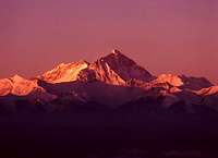
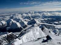
Everest seen from Kala Pattar in February 1986
"Chomolungma or Qomolangma" to Tibetans, meaning "Mother Goddess of
the Earth". "Sagarmatha" meaning "Goddess of the Sky"to the Sherpa
people, (invented in the 1960s by Baburam Acharya in response the the
rising question that the Mountain had no Nepalese name)
Mount Everest gets its European name from British Superintentant
General of the Survey of India 1830-1843, Sir George Everest.
The ancient name for the mountain is Devgiri, meaning "holy
mountain" or Devadurga may have been pronounced it as deodungha by the
English in the 1800s.
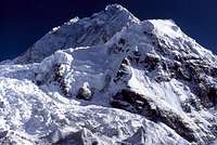
The North face of Everest
One of the first recorded viewings by a European was in 1913 by
Captain John B. Noel.
In 1920 Sir Francis Younghusband received permission for an expedition to
Everest from the Dalai Lama. This first team was headed by Charles Kenneth
Howard-Bury. Climbers on this team included: Harold Raeburn, Alexander
Mitchell Kellas, A.F. R. Wollaston, G. H. Bullock and George Leigh Mallory.
While this expedition failed it did provide important information on the
surrounding area and possible future routes.
Info from mac9805b (in italics)
In 1921 Mallory did a scouting expedition to the base of the west ridge
at Lho La pass (5,981 meters). From here they examined the South Col Route and
named the area below the Lhote Face the "Western Cwm". They also dismissed the
South Col as a possible route, because of the "impassible" Khumbu Icefall.
Since Nepal's borders were closed before World War 2, they would not have been
able to attempt this route.
The 1922 British expedition reached a high point of 8,320 meters. This was
also the first recorded use of bottled oxygen in Mountaineering.
The 1924 British expedition set two height records. The high point of the
expedition was 8,573 meters, which stood as the highest point ever climbed for
29 years until the first ascent in 1953 (assuming Mallory and Irvine did not
summit). It was also the highest point climbed without oxygen for 56 years
until Reinhold Messner and Peter Habeler summited without oxygen from the
South Col. Andrew Irvine's body was discovered by Chinese climber Wang Hong Bo
in 1979 at 8,150 meters. The Chinese said that his camera was not found with
the remains, though some western climbers allege that the Chinese took it. If
they did take the camera, with possible summit photos, it would be buried in
the avalanche that killed Wang Hong Bo the day after discovering the body.
Noel Odell has stated that he saw Mallory and Irvine nearing the base of the
second step at about 12:50 pm on June 8, 1924. He said they appeared to
climbing strongly.
George Mallory's remains were discovered in 1999 by American Big Wall
climber Conrad Anker on the International Mountain Guide expedition led by
Eric Simonson. Mallory was found in a self arrest position, suggesting that
his cause of death was a fall on the descent. His camera was nowhere to be
found.
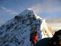
It has been suggested that the 30 meter vertical rock wall called the
second step prevented Mallory and Irvine from summiting in 1924. Due to the
extreme altitude and cold, it has long been considered unclimbable. The
Chinese expedition to the North Ridge in 1975 installed a ladder here, which
is still in use today. However, in 1999 Conrad Anker freeclimbed the second
step by jamming the crack just to the left of the ladder with gloves and
plastic boots.
In 1922, General Charles Granville Bruce, lead another attempt from Tibet.
Climbers on this expedition included: Lieutenant Colonel E. L. Strutt, George
Leigh Mallory, George Ingle Finch, Howard Somervell, William Wakefield, Edward
Felix Norton, Tom Longstaff, Captain John Noel, Geffrey Bruce and John Norris.
This expedition while providing more valuable information also failed along
with the unfortunate death of seven porters.
In 1924, General Charles Granville Bruce again headed an expedition from
Tibet. Climbers included on this team were: Edward Norton, Howard Somervell,
John Noel, Geoffery Bruce, Noel Odell. Bentley Beetham, John de Vere Hazard,
Andrew Irvine, E. O. Shebbeare and Dr. R.W.G. Hingston. This adventure failed
and included the legendary deaths of George Leigh Mallory and Andrew Irvine.
These two climbers were last seen and photographed on June 8th 1924 by
geologist Noel Odell. A man I was privileged to meet at one of his lectures at
McGill University in the early ninteen-eighties. Although he was in his
eighties he was very sharp and I remember that his hands seemed twice the size
of mine.
For eight years the Dalai Lama refused permission for any further
excursions to Everest. Then in 1933 permission was again granted.
Hugh Ruttledge lead a group comprised of: Eric Shipton, Francis Sydney
Smythe,E. St. L. Birnie, Raymond Green, Dr. W. MacLean, Colon Crawford, Percy
Wyn-Harris, Laurence Wager, Jack Longland, Major Hugh Boustead, T.A.
Brockleband, George Wood-Johnson, E.O. Shebbeare, E.C. Thompson and W.R.
Smith-Windham. The route was the North col and unsuccessful.
Eric Shipton lead a group including Harold Tilman, Dr. Charles Warren,
Edwin Kempson, Edmund Wigram, Michael Spender, L.V. Bryant, P.R. Oliver, James
Gavin, W.R. Smyth-Windham, Dr. Noel Humphreys and a young sherpa named
Tenzing Norgay in 1935. They followed the route previously set out by
George Mallory but were unsuccessful at reaching the summit. The
expeditions of '35, 36' & '38 are all sort of lumped into one, described as
'35. Hence, some of the members of '36 and '38, who were not on the '35
expedition. A correct listing of expeditions and expedition members can be
found at:www.billbuxton.com/BritishEverest21-53.pdf
info thanks to
Bill
Buxton
In 1947 a Canadian named Earl Denman and two sherpas secretly attempted
the north col route but failed.
In 1950 the Chinese invaded Tibet thus closing the border to Europeans for
a couple of years.
Spring of 1951 saw a Dane, Klas Becker Larsen attempt Everest for the
first time going through Nepal. Crossing a pass west of Cho Oyu. Bad weather
conditions and possible arrest by the Chinese forced him to abandon his
attempt of the north col.
The fall of the same year 1951 saw another British attempt lead again by
E.E. Shipton. Team members wre: Micheal Phelps Ward, Thomas Duncan Bourdillon,
William Hutchison Murray, Dr. Dutt, Edmound Hillary and H.E. Riddiford. This
time the mountain was to be attempted by the south col route in Nepal. The
team succeeded in getting above the icefall but no further and were
unsuccessful.
The spring of 1952 saw a team of Swiss lead by E. Wyss-Dunant, which
included. Renittert, Androch, Raymond Lambert, Ernst Hofstetter, Jean Jacques
Asper, Gabriel Chevalley, Leeon Flory and Tenzing Norgay. Halted by bad
weather in the south col this team was unsuccessful.
The fall of 1952 saw a new team of Swiss lead by Gabriel Chevalley, which
now included. Raymond Lambert, Gustave Gross, Ernest Reiss, Jean Busio, Arthur
Sp?, Normand Dyhrenfurth (an American) and Tenzing Norgay. Halted by bad
weather and the death of a Sherpa this team was unsuccessful.
Some notable successes
Many Thanks to Mark (aka. Vertx) for the work on the table.
1984 Bulgarian West Ridge expedition . Author: taikavuorimies
Date: Jan 12, 2006 1:58 PM On April 20 1984 Hristo Prodanov became the
first Bulgarian to summit mount Everest and the first man ever to scale the
West ridge solo and without the use of supplemental oxygen. He died while
trying to descend through the West ridge. On May 8-9 four members of the same
expedition made the first full traverse of Everest - ascent through the West
ridge and descent through the South-East ridge (Hornbein's team did not follow
the West ridge completely, they passed through the Hornbein Couloir). These
four men were Ivan Valchev, Metodi Savov, Nikolai Petkov and Kiril Doskov. No
one has scaled the West ridge since that expedition.
First ski descent & first married couple . Author: alex_vega
Date: Dec 28, 2005 11:52 AM Mt. Everest, October 7, 2000 It was a
historical day for Slovenian. Davo Karnicar, of Jezersko, Slovenia,
accomplished an uninterrupted ski descent from the top of the world's highest
mountain, Mount Everest (8,848m). At 8 a.m. local time (4.15 CEST), Davo
started his historical ascent, fulfilling his longtime dream to which he had
aspired since 1996 when a snowstorm halted his efforts. Today, in only five
hours, Davo skied uninterruptedly (without taking skis off) from the top of
the mountain to base camp at 5,340m. (copied from www.k2news.com) Andrej and
Marija Stremfelj , first married couple on world , that is together climbed
Everest on October 7 , 1990.
Pemba Dorje Sherpa, new speed record, 8 hours and 10 minutes on May
21, 2004
There must be more...... First International Hairdressers ascent ... Monty
Python.
Items of interest
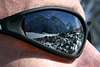
Alistair Sutcliffe's shot from the top
Current items of interest.
Hungarians on Everest!
On the 23rd of May, 2007 the second hungarian climber, Attila Jelinkó has
reached the summit of Mount Everest at 3 o'clock am /CET/. The first was Zsolt
Erõss in 2002. Attila Jelinkó is the first non professional hungarian climber
who climbed Chomolungma!
New book out on the Himalyan Data Base of Elizabeth Hawley
http://URL_HERE
SP members summit bids

Kantega, 22,235 (6856m) in the Khumbu, South of Everest as seen from the
village Periche.
Read about SP member Alans Arnette’s 2003 south Col summit attempt on
Everest.
Check here
or here
SP member
Kevin
Donovan attempted the North Face of Everest. You can read about it hereexpeditioneverest.com
Adventure Peaks handled all the
lodgistics for this expedition. Just a couple of quick items on the
expedition. Enjoy! From MountEverest.Net
www.mounteverest.net Photos of Gear - Before & After
www.expeditioneverest.com More
Just for fun! Link to
a Panorama from
the summit of Everest. Provided by vertx Times of India article on
Spirits on Everest
Getting There
[img:66374:alignleft:small:The huge bulk of Mount Everest rises above the
Nuptse wall.
A jet-stream driven plume of snow is an indication of the conditions up
there.]To get to Nepal you will have to fly from either India, Thailand or
Singapore. To get to New Delhi India try (there are many others).
Air India
British Airways
Air France
Air Canada
Kuwait Airlines
Qatar Airways
Lufthansa
KLM
Royal Air Nepal
Once you get to Katmandu you will have basically two options:
1 - Fly on Royal Air Nepal's Twin Otter flights to Lukla. A small air strip
about ten days from Everest Base Camp (eight from Gokyo peak allowing for
acclimitization) 1 hour flight approx. 2 - Take a local bus, Mini Bus hired by
you or your Sherpa provider to Jiri. This is a small village at the end of the
road. From here it is about a 14-16 day trek to the Kumbu region.
If you have the time do the walk. For three reasons:
1 - You will have a chance to walk through one of the most lush and
beautiful lowland areas in Nepal. This is an area that a lot of trekkers miss
when flying to Lukla. You will also cross over two high passes with excellent
views in all directions.
2 - By taking 2 weeks to arrive in the Khumbu are and having already
crossed over two high passes you will be better acclimitized once you arrive
in the high peaks area. You will enjoy this more as you will be huffing and
puffing less.
3 - You will be following the route taken by most of the early expeditions.
There is a lot of history along that path, why not soak it up. You will also
have the bragging rights that you did the same route as they in years gone by.
Flying is fast and that has its advantages. But if you have ever been at
Lukla after several day s of no flights after bad weather you will understand
this. (Trekkers fighting over seats to make their connecting flights home)
Note on recent bus cancellation to Juri Author: vito corleone
Date: May 19, 2004 05:08 AM At the moment it is not possible to take the bus
to Jiri. There are no busses going to the east of Nepal from Kathmandu because
maoists shot at a public bus and killed several people, including civilists.
After that, all the bus services were suspended. Nobody knows when the busses
will be going again. If you really want to go to Jiri dispite of the worsening
security situation (probably not a good idea) you have to hire a car.
Nepal News story Still, there are no problems with maoists above Lukla.
For Chinese (north side) Fly to Beijing, then to Lhasa, in occupied Tibet. Bus
or truck to basecamp very long and dusty and no relief from altitude gain.
Red Tape
There are permits required. These can be arranged by yourself or the firm
that you hire to support your team. There is also an entry visa to Nepal. The
below can be of help. Permits The
General Secretary, Nepal Mountaineering Association Post Box No. 1435,
Kathmandu. Chinese to come
Helping the Sherpa/Tibetan community

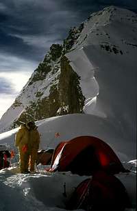
Above the third step on Everest
There are several organizations dedicated to helping the Sherpa community.
Here are just two. Should you wish to contribute to this worthwhile cause
contact either of the following organizations though the information below.
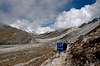
The walk in from Lukla
The Khumbu Icefall in 1982
Flying into Lukla 9,350 ft.: (Note walking times are approximate a lot will
depend on how you acclimitize.)
Slowly decend to Phakding 8,700 ft. about 2 hr walk from Lukla, you will
probably overnight here.
The next morning after about 2-3 hours you will pass through Jorsale 9,100
ft. Here is where you will pay a fee and enter the Sagarmatha (Everest)
National Parkand. You will then continue for another 2-3 hours up hill to the
main Village of Namche Bazaar 11,300 ft. This is quite an elevation gain
especially for those who have flown in. You should rest here one to two days,
doing small side trips ect. to acclimitize.
The next day will take you through Shyangboche 11,800 ft. (approx) then
onto the village of Khunde 12,600 ft. then onto Khumjung 12,400 ft. then you
decend to near the river crossing at 10,650 ft. Cross over at Pungo Tenga.
Then it is uphill for two hours to Tengboche. This is another good rest spot.
The following day continue east out of the settlement and down 1.5 hours to
Pangboche 12,800 ft. (keep right). Continue for 1.5 hours till you reach a
fork in the trail. Go left donw to the river and cross over and uphill to the
village of Pheriche (13,950 ft.). Stop here for the night. Here there is a
Hospital for treating altitude illnesses. The next day or so go north along
the valley floor to the end and then up to the north-east along the glacial
moraine past Dunhla (15,075 ft.) (Climbers memorials) to the Village of
Labouche (16,175 ft.) another 2-4 hours will bring you to Gorak Shep. From
here you can go to Kala Pattar (18,450 ft.) or Everest Base Camp (17,575 ft.)
or if you are going to Nupste you will have to cross the moraine to it’s base.
Guided Climbs
If you are not able to be on an Official Expedition try one of these guided
ascents
Alpine Ascents International
Adventure Consultants
Himalaya Expeditions
Earth Treks
Jagged Globe
Mountain-Link
Expeditions
Mountain Madness
Mountain Odyssey
Adventure Peaks
Adventures International Inc.
Mountain Guides
7summits.com
Avoiding Altitude sickness
You should be prepared for the possible onset of altitude sickness. High
altitudes are stressful on the body, and lack of oxygen up high can produce
slightly debilitating effects, such as fatigue, headaches, shortness of
breath, loss of appetite, nausea, and a drunken gait. Altitude sickness
generally doesn't occur below 10,000 feet, but people have suffered its
symptoms lower than 8,000 feet.
There's not much you can do to prevent this problem, but there are ways of
alleviating its effects. The key to doing this is simple: take it easy. Take a
day or two before beginning the walk in to acclimatize yourself to the
elevation. Go at your own pace, and don't take chances. Even if you're in
excellent shape, don't be fooled. The lack of oxygen at such high altitudes
can definitely throw your lungs for a loop. Walk at a comfortable, slow pace
and don't carry too much weight. Make sure to hydrate yourself regularly,
drinking 4 to 5 liters (nalgene bottles) of water per day; On some climbs
camelbacks can be mountain companions because of their convenient water
portability. The only problem being keeping the nozzle clean, I find they can
get gross and need constant cleaning. My self I attach a 1 litre Nalgene
bottle to each side of my backpack so that I can reach them easily without
removing my pack. These solutions would have to be modified to suit the
weather and conditions of climbing Everest. Bottles would have to be insulated
and the tube from the camelback could tend to freeze up. Taking antioxidant
vitamin s (A, C, and E) also helps reduce the effects of high altitudes. Of
course working out before you go is another great preventative measure. While
this doesn't guarantee an easier time when up high, it can enhance your lungs'
ability to cope with the challenges of high elevations.
Try to spread out your ascent over a period of two or three days to give
your body more time to adapt. Play by the "climb-high, sleep-low" theory of
ascent: go on a short hike to a higher elevation, then return to the (lower)
elevation at which you'll sleep.
Physical fitness, as mentioned above, is no guarantee against developing
altitude sickness. Past excursions to high elevations without developing
symptoms is similarly no guarantee against getting sick. There's no way to
predict who is more susceptible to altitude sickness, although climbers who
overexert themselves, those who are panting or breathless, and those who
stagger far behind the rest of the group are likely candidates.
Surefire signs of impending illness include extreme fatigue, headache,loss
of appetite, and shortness of breath. If you experience any of these symptoms,
the best thing to do is take a break from climbing for a couple days to
acclimatize. Once the symptoms disappear, it's safe for you to continue. If
the symptoms persist or get worse, you should descend to a lower elevation.
More serious levels of the illness include increasing tiredness, severe
headaches, vomiting, and loss of coordination, and are indicative of acute
mountain sickness (AMS). If such symptoms appear, don't hesitate to get
immediate medical attention. If serious symptoms go ignored for more than 12
hours, they could have dire--even fatal--effects, such as accumulation of
fluid in the lungs or brain. The most important symptom of AMS is loss of
coordination. If someone staggers or walks in a drunken gait, check them out
for further signs of AMS. A good test is, essentially, the police's test for
drunkenness--ask the person to walk in a straight line, placing one foot di
rectly in front of the other without staggering or losing balance. If the
person cannot perform, he or she should descend immediately--and never alone.
Go slowly and without exertion, and ideally while it's light outside. Descend
should continue until symptoms beg in to decrease; relief usually occurs
within 1,000 to 1,500 feet.
There are prescription drugs out there that you can take for severe
symptoms. One of the most common is called Diamox; it works by stimulating
your breathing. Diamox is a strong medication and has some slight side
effects, such as an annoying tingling in the fingers and toes. You will
urinate more frequently so getting out of the tent at night in a storm could
be a problem (if you don't use a pee bottle). This will also necessitate you
drinking more fluids to compensate. If you take too much you can get very ill.
My advice is avoid taking it if if you can.
Possible acclimitisation schedule for the South col route
Author: trunl Date: Jan 25, 2005 9:33 PM
Trek to BC- 10 days
Arrival BC April 1
Climbing C1 April 7
Back to BC April 8
Climbing C2 April 11
Back to BC April 13
Climbing C2 April 17
Climbing C3 April 19
Back to BC April 20
Trekking down April 21
Back to BC April 26
1st summit attempt May 1-7
Trekking down May 7-12
Back in BC May 13
Last summit attempts May 16-30
Mountain Conditions
Everest. Now that's a route, Alistair Sutcliffe
Reading anyone of these fine books will give you the picture of the
conditions to be faced.
Mount Everest : The Reconnaissance 1935
Author: Tony Astill
Date: Dec 01, 2005 06:22 AM
This new book, just published by the author in December 2005 is available
from him. Please contact Tony Astill directly by post
'Arcadia' Hazel Grove, Ashurst, Southampton SO40 7AJ England.
Tel [44] (0) 2380293767 or email alpes@supanet.com
This is a hardback book of 360 pages, with 125 photgraphic illustrations
now seen for the first time and 10 maps [3 folding]. The unique double dust
jacket shows the fine map of the north face of Everest by Michael Spender. Ed
Webster says 'I got my copy of your book today. I have just finished flipping
through the entire book tonight, admiring each and every page, and sensational
is the only word capable of describing your multiple accomplishments of
writing, digging, researching, assembling, and publishing this monumental,
vital, comprehensively detailed, exceptionally interesting, and historically
significant book.'
Annapurna, by Maurice Herzog will fill you in on frostbite. New Paper back
issue is on the stands now.
Everest:Expedition to the Ultimate Reinhold Messner/Pape rback/Published
1999
Other Side of Everest : Climbing the North Face Through the Killer Storm
Matt Dickinson / Hardcover / Published 1999
Everest again, May 1996 again, this time on the Tibetan side, in a tedious,
self-obsessed account from filmmaker Dickinson. While Krakauer and company
were toiling up the southern, Nepalese side of Everest three years back,
Dickinson was part of a commercial climb on the North Face.
Doctor on Everest : Emergency Medicine at the Top of the World - A Personal
Account Including the 1996 Disasterby Ken Kamler, Kenneth Kamler, Edmund
Hillary
View from the Summit by Edmund Hillary
Everest: The West Ridge by Thomas F. Hornbein
The Madman Of Everest by Ann Livesay
Climbing Everest : A Meditation on Mountaineering and the Spirit of
Adventure by Pat Ament
Everest : Alone at the Summit (Adrenaline Classics Series) by Stephen
Venables (Editor). Paperback (August 15, 2000)
Everest : The Struggle to Reach the Top of the World by Geoff Tibballs
Left for Dead : My Journey Home from Everest by Beck Weathers, Stephen G.
Michaud (Contributor)
Everest : A Mountaineering History' by Walt Unsworth Hardcover - 736 pages
Reprint edition (October 1999)
Ghosts of Everest; The Search for Mallory & Irvine by Jochen Hemmleb, Eric
Simonson, Larry Johnson
Eric Shipton: Everest & Beyond Edmund Hillary, Peter M.D. Steele
/Paperback/Published 1999
A Life on the Edge: Memoirs of Everest and Beyond -- Jim Whittaker, et al;
Hardcover 272 pages September 1999
Climbing High: A Woman's Account of Surviving the Everest Tragedy Lene
Gammelgaard / Hardcover /Published 1999
Into Thin Air :The Illustated Version ~by Jon Krakauer Hardcover - 378
pages illustrated edition
Everest : Mountain Without Mercy - Broughton Coburn, et al; Hardcover
The Climb : Tragic Ambitions on Everest - Anatoli Boukreev, G. Weston
Dewalt; Hardcover
East of Everest Bob Langley / Hardcover / Published 1986
Into Thin Air : A Personal Account of the Mount Everest Disaster ~ Jon
Krakauer / Hardcover / Published 1997
Mount Everest National Park : Sagarmatha Mother of the Universe ~ Margaret
Jefferies / Paperback / Published 1991
The Right Mountain : Lessons from Everest on the Real Meaning of Suc cess ~
Jim Hayhurst / Paperback / Published 1997
Sir Edmund Hillary : To Everest and Beyond (Newsmakers) ~ Whitney Stewart,
et al / Library Binding / Published 1996
The Crystal Horizon : Everest-The First Solo Ascent Reinhold Messner /
Paperback / Published 1998
A Deathful Ridge : A Novel of Everest ~ Andy Wainwright, J. A. Wainwright /
Hardcover / Published 1997
The Boardman Tasker Omnibus : Savage Arena, the Shining Mountain, Sacred
Summits, Everest the Cruel Way ~ Peter Board man (Editor), Joe Tasker (Editor)
/ Hardcover / Published 1995
Everest : The History of the Himalayan Giant ~Roberto Mantovani, et al /
Hardcover / Published 1997
If you can get your hands on the original book on the first ascent in 193
by Sir John Hunt do so its good reading. I have a copy somewhere, and will
provide the info later. Try your local library or the web.
Note on The John Hunt Everest book
Author: nchenkin The first ascent was in 1953, Hunt's book was titled
simply The Ascent of Everest There were five printings of the first edition.
The fourth printing has a fold-out elevation chart, which is not present in
other printings.
When the book was released in the U.S. title was unfortunately changed to
The Conquest of Everest. There are plenty of copies of both available in used
book site on the web. Plus, it was reissued, as The Ascent of Everest in
paperback by The Mountaineers in 1993. Thanks for this nchenkin. Cheers
William
Brief gear list
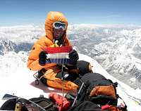
Harry Kikstra on the summit of Everest, 2nd June 2005. Windy, but
with a great view.
Partial Equipment list info:
Here is a brief incomplete list for you. Minus the Climbing gear
6-pairs socks
6-underwear
2-pairs of shorts for the walk in
3-T-shirts for the walk in
2-bandanas or a sun hat to keep off the sun
Sunscreen, sunscreen, sunscreen plus zinc
Good sturdy hiking shoes
1-sleeping bag (as warm as you can get)
1-sleeping pad (your choice the more comfortable you are the better you
sleep the more energy you will have) you can get a Crazy Creek chair that goes
with your pad this is a good investment.
2-expedition weight Patagonia long underwear tops (or 1 depends on how
dirty you like to be)
1-expedition weight Patagonia long underwear bottom
1 lightweight fleece bottom
1-heavy weight Patagonia or similar fleece jacket
1-Gortex shell jacket
1-Gortex shell pants (full length zippers)
1-Down filled jacket liner from Feathered Friends of Seattle, (optional
but I always end up using it)
1-D own filled Gortex guides Parka 1-Warm hat with ear flaps
2-pairs of heavy duty mittens (in case you lose one pair up high)
1-pair fleece gloves 1-pair ski gloves
1-pair of Koflach double plastic boots, One Sport (much warmer)($$$) or
Asolo (I prefer Koflach, I find them more comfortable)
1-pair of gaitors (Super Gators)
1-pair ski poles
1-ice axe
1-pair of sharp crampons (test them on your boots before you leave and
make sure they fit perfectly)
1-headlamp with extra batteries a nd bulbs
1-cup with spoon attached
1-Swissarmy knife
1- stove of your choice (I use Markhill stormy hanging stone with Blueway
cartridges, you will have to get fuel in Nepal as it is difficult to fly over)
Allow at least 1 canister per day for up high per 2-man tent.
1-4 tents one set up at base camp. one at camp 1, and another 2 for higher
up. 3-1-litre waterbottles with insulators (drink at LEAST 5 litres a day to
help acclimatize) Food....
The discovery of Everest, the highest mountain in the world, was the
crowning achievement of labors by geographers, surveyors, and explorers. It
was as demanding and complicated an achievement as the mountaineering and
logistical skills of those who eventually climbed it. Both endeavors faced
formidable obstacles – physical, psychological, political, and technical –
that often appeared insurmountable.